Category:Satellite pictures of Africa
Jump to navigation
Jump to search
Temperate regions: Africa · Asia · Europe · North America · Oceania · South America – Polar regions: Antarctica ·
Satellite pictures of the continent of Africa (or major features there of), plus satellite pictures of individual countries in their respective sub-categories.
Subcategories
This category has the following 75 subcategories, out of 75 total.
!
*
+
- Satellite pictures of Ceuta (20 F)
A
- Africa at night seen from space (200 F)
B
- Satellite pictures of Benin (24 F)
C
- Satellite pictures of the Comoros (254 F)
D
E
- Satellite pictures of Eswatini (35 F)
G
- Satellite pictures of Gabon (30 F)
- Satellite pictures of the Gambia (66 F)
- Satellite pictures of Ghana (215 F)
- Satellite pictures of Guinea (143 F)
I
K
L
- Satellite pictures of Lesotho (47 F)
- Satellite pictures of Liberia (17 F)
M
N
R
S
- Satellite pictures of Seychelles (401 F)
T
- Satellite pictures of Togo (24 F)
U
W
- Satellite pictures of Western Sahara (235 F)
Z
Media in category "Satellite pictures of Africa"
The following 95 files are in this category, out of 95 total.
 187 1003703 africa dxm.png 2,048 × 2,048; 2.98 MB
.jpg/120px-2019-03-20%2C_Sentinel-1B_GRD_IW%2C_Custom_script_(46705994884).jpg) 2019-03-20, Sentinel-1B GRD IW, Custom script (46705994884).jpg 2,101 × 1,185; 1.53 MB
2019-03-20, Sentinel-1B GRD IW, Custom script (46705994884).jpg 2,101 × 1,185; 1.53 MB
_PROBAV_S1_TOC_333M.jpg/120px-2021-01-13-00_00_2021-01-13-23_59_Proba-V_1_day_(S1)_PROBAV_S1_TOC_333M.jpg) 2021-01-13-00 00 2021-01-13-23 59 Proba-V 1 day (S1) PROBAV S1 TOC 333M.jpg 1,024 × 528; 145 KB
2021-01-13-00 00 2021-01-13-23 59 Proba-V 1 day (S1) PROBAV S1 TOC 333M.jpg 1,024 × 528; 145 KB
_(cropped)_Magreb.jpg/120px-Africa_(satellite_image)_(cropped)_Magreb.jpg) Africa (satellite image) (cropped) Magreb.jpg 2,463 × 1,150; 431 KB
Africa (satellite image) (cropped) Magreb.jpg 2,463 × 1,150; 431 KB
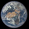
.jpg/120px-Africa_(satellite_image).jpg) Africa (satellite image).jpg 5,723 × 5,563; 3.36 MB
Africa (satellite image).jpg 5,723 × 5,563; 3.36 MB
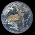
.jpg/120px-Africa_and_Europe_from_a_Million_Miles_Away_(19931748669).jpg) Africa and Europe from a Million Miles Away (19931748669).jpg 2,048 × 2,048; 648 KB
Africa and Europe from a Million Miles Away (19931748669).jpg 2,048 × 2,048; 648 KB
.png/120px-Africa_and_Europe_from_a_Million_Miles_Away_(cropped).png) Africa and Europe from a Million Miles Away (cropped).png 1,662 × 1,663; 3.38 MB
Africa and Europe from a Million Miles Away (cropped).png 1,662 × 1,663; 3.38 MB
 Africa and Europe from a Million Miles Away.jpg 1,780 × 1,768; 281 KB
 Africa and Europe from a Million Miles Away.png 1,780 × 1,768; 3.68 MB
.jpg/115px-Africa_at_night_(Cropped_From_Entire_Earth_Image).jpg) Africa at night (Cropped From Entire Earth Image).jpg 3,907 × 4,089; 2.24 MB
Africa at night (Cropped From Entire Earth Image).jpg 3,907 × 4,089; 2.24 MB
 Africa extreme points.jpg 768 × 768; 372 KB
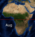 Africa FebAug.gif 1,020 × 1,082; 1.24 MB
 Africa from low orbiting satellite Suomi NPP.jpg 11,500 × 11,500; 11.04 MB
 Africa satellite orthographic 2.jpg 1,828 × 2,052; 533 KB
 Africa satellite orthographic.jpg 1,624 × 1,824; 535 KB
.jpg/120px-Africa_satellite_plane_(cropped-egypt).jpg) Africa satellite plane (cropped-egypt).jpg 1,325 × 1,193; 240 KB
Africa satellite plane (cropped-egypt).jpg 1,325 × 1,193; 240 KB
 Africa satellite plane.jpg 8,460 × 8,900; 7.34 MB
 Africa satellite.jpg 900 × 900; 472 KB
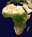
 Africa terrain.jpg 1,002 × 960; 102 KB
 Africa topic image Satellite image.jpg 4,868 × 3,245; 6.71 MB
 Africa-locator.jpg 209 × 219; 35 KB
 African mosaic ESA360518.jpg 2,000 × 1,810; 2.14 MB
 Apollo 17 - Blue Marble 2.0 Project.png 7,492 × 8,022; 35.59 MB
.jpg/115px-AS09-22-3408_(21413685343).jpg) AS09-22-3408 (21413685343).jpg 4,400 × 4,600; 1.09 MB
AS09-22-3408 (21413685343).jpg 4,400 × 4,600; 1.09 MB
.jpg/115px-AS09-22-3409_(22022495072).jpg) AS09-22-3409 (22022495072).jpg 4,400 × 4,600; 1.16 MB
AS09-22-3409 (22022495072).jpg 4,400 × 4,600; 1.16 MB
.jpg/115px-AS09-22-3410_(21846667260).jpg) AS09-22-3410 (21846667260).jpg 4,400 × 4,600; 1.2 MB
AS09-22-3410 (21846667260).jpg 4,400 × 4,600; 1.2 MB
 Blue Marble December 7 2022.jpg 2,500 × 2,500; 3.4 MB
.jpg/120px-Central_Africa_Appears_to_Be_Completely_On_Fire_(27993210770).jpg) Central Africa Appears to Be Completely On Fire (27993210770).jpg 1,634 × 1,268; 980 KB
Central Africa Appears to Be Completely On Fire (27993210770).jpg 1,634 × 1,268; 980 KB
.jpg/106px-Congo_River_2017_02_03_(32647822096).jpg) Congo River 2017 02 03 (32647822096).jpg 3,312 × 3,746; 3.69 MB
Congo River 2017 02 03 (32647822096).jpg 3,312 × 3,746; 3.69 MB
 Congo River basin from space.png 1,527 × 970; 1.54 MB
 Congo River, Africa ESA203391.tiff 2,858 × 2,598; 27.19 MB
 Congo River, Africa.jpg 2,858 × 2,598; 4.53 MB
 Desert greenery ESA19443666.tiff 6,295 × 9,293; 167.39 MB
.jpg/120px-Dust_from_Sahara_2017_05_10_(33735828734).jpg) Dust from Sahara 2017 05 10 (33735828734).jpg 4,272 × 2,446; 2.09 MB
Dust from Sahara 2017 05 10 (33735828734).jpg 4,272 × 2,446; 2.09 MB
 Earth on August 7, 2022.png 2,048 × 2,048; 3.15 MB
 East Africa and Middle East - AATSR - 11 April 2002 ESA195373.jpg 512 × 5,000; 524 KB
 Emma 26 Feb 18.png 1,343 × 933; 2.38 MB
 Epic 1b 20151030095041 00.png 2,048 × 2,048; 3.28 MB
 Ethiopia from space.png 1,527 × 970; 1.8 MB
 EurAfrAsi3x2x152 2.jpg 455 × 247; 57 KB
 Fiona, Gaston, Hermine and 09L on September 23, 2022.png 6,670 × 4,170; 53.35 MB
 Galileo image of Antarctica and Africa.gif 702 × 720; 258 KB
 Great African Lakes from space.png 1,527 × 970; 1.53 MB
 Great Rift Valley NASA.jpg 199 × 599; 9 KB
 GreatLakesAfrica.jpg 279 × 286; 17 KB
 Gulf of Guinea 5.24136E 2.58756N.jpg 1,280 × 958; 113 KB
.jpg/120px-Horn_of_africa_(cropped).jpg) Horn of africa (cropped).jpg 5,699 × 814; 1.08 MB
Horn of africa (cropped).jpg 5,699 × 814; 1.08 MB
 Horn of africa.jpg 5,699 × 4,502; 4.62 MB
 ISS-40 Africa and Iberian Peninsula toward Strait of Gibraltar.jpg 4,256 × 2,832; 1.15 MB
.jpg/120px-ISS-43_Canadarm2_grapples_CRS-6_Dragon_over_northern_Africa_(ISS043-E-124641).jpg) ISS-43 Canadarm2 grapples CRS-6 Dragon over northern Africa (ISS043-E-124641).jpg 4,928 × 3,280; 1.79 MB
ISS-43 Canadarm2 grapples CRS-6 Dragon over northern Africa (ISS043-E-124641).jpg 4,928 × 3,280; 1.79 MB
 ISS-57 North Africa and the Mediterranean Sea.jpg 5,568 × 3,712; 1.67 MB
.jpg/120px-ISS-59_SpaceX_CRS-17_Dragon_approaches_the_ISS_(2).jpg) ISS-59 SpaceX CRS-17 Dragon approaches the ISS (2).jpg 4,928 × 2,768; 1.59 MB
ISS-59 SpaceX CRS-17 Dragon approaches the ISS (2).jpg 4,928 × 2,768; 1.59 MB
.jpg/120px-ISS-59_Tropical_Cyclone_Idai_(1).jpg) ISS-59 Tropical Cyclone Idai (1).jpg 5,568 × 3,712; 3.15 MB
ISS-59 Tropical Cyclone Idai (1).jpg 5,568 × 3,712; 3.15 MB
 ISS-60 HTV-8 grappled by Canadarm2 to attach it to the ISS.jpg 5,568 × 3,712; 1.97 MB
.jpg/120px-ISS-65_Nauka_and_Soyuz_MS-18_docked_to_the_International_Space_Station_(1).jpg) ISS-65 Nauka and Soyuz MS-18 docked to the International Space Station (1).jpg 5,568 × 3,712; 2.45 MB
ISS-65 Nauka and Soyuz MS-18 docked to the International Space Station (1).jpg 5,568 × 3,712; 2.45 MB
 Jers 1 africa.tif 2,552 × 997; 4.56 MB
 Karoo ecoregion.jpg 644 × 496; 114 KB
 Lake Chad from Apollo 7.jpg 2,415 × 1,811; 1,000 KB
 Lake Chad satellite.jpg 832 × 624; 252 KB
 Lake Malawi, Great Rift Valley ESA205475.tiff 3,293 × 3,482; 39.15 MB
 Lakes of Africa ESA220270.tiff 4,261 × 4,296; 35.8 MB
 Lakes of Africa.jpg 4,261 × 4,296; 7.42 MB
 Luftbild Westafrika.jpg 800 × 665; 97 KB
 Map of Africa With Colors.jpg 728 × 800; 195 KB
.jpg/120px-Mediterranean_Sea_(cropped).jpg) Mediterranean Sea (cropped).jpg 1,804 × 925; 585 KB
Mediterranean Sea (cropped).jpg 1,804 × 925; 585 KB
 Mediterranean Sea 16.61811E 38.99124N.jpg 2,046 × 1,496; 720 KB
 Mediterranean Sea political map-blank.svg 2,046 × 1,496; 1.06 MB
 Mediterranean Sea political map-en.svg 2,046 × 1,496; 1.11 MB
 Mediterranean Sea political map-es.svg 2,046 × 1,496; 1.1 MB
 Mediterranean Sea political map-fr.svg 2,046 × 1,496; 1.1 MB
 Mediterranean Sea political map-hr.svg 2,046 × 1,496; 3.13 MB
 Mediterranean Sea political map-it.svg 2,046 × 1,496; 1.33 MB
 Mediterranean Sea political map-ku.svg 2,046 × 1,496; 1.07 MB
 Mediterranean Sea political map-mk.svg 2,046 × 1,496; 1.09 MB
 Mediterranian Sea places blank.jpg 2,046 × 978; 508 KB
 MERIS mosaic of Africa - May 2004 ESA227803.jpg 1,240 × 1,240; 308 KB
 MERIS mosaic of Africa - May 2004 ESA227803.tiff 1,240 × 1,240; 2.7 MB
 NASA - Visible Earth, Lakes of the African Rift Valley.jpg 1,000 × 654; 127 KB
 Nasa Horn of Africa.JPG 2,920 × 2,655; 1.06 MB
 Nasa mosaico africa central.jpg 600 × 234; 19 KB
 Nasa-Horn of Africa.jpg 659 × 599; 81 KB
 Nigeria from space.png 1,527 × 970; 1.43 MB
 Ostafrika.jpg 700 × 900; 202 KB
.gif/120px-Saharan_Dust_Atlantic_Suomi_NPP_VIIRS_Animation_(26501111033).gif) Saharan Dust Atlantic Suomi NPP VIIRS Animation (26501111033).gif 1,221 × 758; 3.09 MB
Saharan Dust Atlantic Suomi NPP VIIRS Animation (26501111033).gif 1,221 × 758; 3.09 MB
 The Horn of Africa ESA224836.tiff 3,189 × 2,634; 24.89 MB
 The Horn of Africa.jpg 3,189 × 2,634; 6.21 MB
 The Nile from space.png 1,527 × 970; 1.85 MB
 Too hot to handle ESA19642327.gif 2,029 × 1,813; 3.38 MB
 Virunga Mountains ESA294957.tiff 7,015 × 5,760; 115.64 MB
 Virunga Mountains ESA368326.jpg 1,920 × 1,383; 5.1 MB
 West Africa ASAR, 11 November 2003 ESA210473.jpg 1,024 × 1,400; 398 KB
 West Africa ASAR, 11 November 2003 ESA210473.tiff 5,519 × 7,546; 158.89 MB
 África Subsahariana.jpg 565 × 438; 36 KB
 תמונת לווין-הים התיכון.JPG 529 × 269; 33 KB

.jpg)
_PROBAV_S1_TOC_333M.jpg)
_(cropped)_Magreb.jpg)
.jpg)
.jpg)
.png)


.jpg)


.jpg)


.jpg)
.jpg)
.jpg)

.jpg)
.jpg)


.jpg)


.jpg)

.jpg)
.jpg)

.jpg)


.jpg)


.gif)


.jpg)